Remote sensing
Landscape assessment at grassroots via geoinformatics

An intriguing and unique European research initiative, supervised by Greek experts, seeks to develop approaches and methodologies for assessing landscape quality in rural regions in order to safeguard it.
In fact, it employs as its primary tools, on the one hand, citizen engagement and, on the other, the most advanced technologies of geoinformatics and artificial intelligence.
Over 82,600 hectares consumed in Evros by Aug 28, fresh satellite data show

The fire in Evros, located in northeastern Greece, had consumed an area exceeding 82,600 hectares until August 28. This information is based on the latest high-resolution images obtained from the Sentinel-2 satellite and analyzed by the National Observatory of Forest Fires (NOFFi)'s burnt areas mapping service.
AI recruited in effort to prevent forest fires

Artificial intelligence is being deployed in the battle for the prevention and management of forest fires through innovative programs developed and coordinated by the National Observatory of Athens (NOA).
More specifically, forest fire risk is being assessed through the Deep Cube and SeasFire programs, which started in January 2021 and March 2022 respectively.
- Read more about AI recruited in effort to prevent forest fires
- Log in to post comments
German satellite sends images of Bosphorus

The German environmental satellite mission Environmental Mapping and Analysis Program (EnMAP) has delivered its first images a month after its launch.
As part of the mission, which is managed by the German Aerospace Center (DLR), EnMAP has recorded a strip about 30 kilometers wide and 180 kilometers long over Istanbul.
- Read more about German satellite sends images of Bosphorus
- Log in to post comments
Satellite images show bodies lay in Bucha for weeks, despite Russian claims
Satellite images provided to The Times by Maxar Technologies show that at least 11 of those had been on the street since March 11
Turkey: Images from Space Show Dramatic Scenes of Fires in Turkey

High-resolution photos were taken by the American observation satellite WorldView-2 from Maxar from an altitude of 770 km.
High-resolution satellite images of large-scale forest fires in the Turkish resorts of Bodrum, Manavgat and Marmaris have been published by European Space Imaging.
Digital Card Guides Volunteers in 'Let's Clean Bulgaria Together' Campaign

The Green Card of the largest volunteer initiative in Bulgaria - Let's Clean Bulgaria Together - will become the first assistant and virtual guide to all environmentalists and ambassadors of the good example.
Greek micro-satellites on route to International Space Station (video)

The two Greek micro-satellites, UPSat and DUTHSat, are on route for the International Space Station after being launched into space on Tuesday.
India successfully launched 104 satellites!

India slowly but steadily becomes an important international player in the space sector. On Wednesday India made yet another important step towards that direction, as the country successfully launched 104 nano-satellites into orbit.
Of the 104 satellites, 96 belong to the USA, one to Israel, Kazakhstan, the Netherlands, Switzerland and the UAE.
- Read more about India successfully launched 104 satellites!
- Log in to post comments
Scientists survey the last hidden region of South Pole (photos)
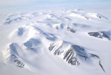
The last unknown part on earth, the South Pole, has finally been surveyed. European scientists have used instruments to the region to map its hidden depths. Known as PolarGAP, the project was largely funded by the European Space Agency (Esa) to gather measurements over an area of Earth that its satellites cannot see, as they generally only fly up to about 83 degrees in latitude.